The biggest danger on planet Earth
Any collision of the Earth with a cosmic body of a sufficiently large size will inevitably lead to some standard situation that threatens all life on our planet
2022-06-24 05:46
Than they just didn’t frighten us - from the fears of the biblical "global flood" to the horrors of nuclear war, from terrible global epidemics to attacks by space aliens. Literature, cinema and animation compete in creating frightening pictures of the death of all living and non-living things on a planetary scale.
When reality is scarier than fiction
But from biblical times to the present day, neither the inquisitive mind of the scientific community, nor the rich imagination of science fiction writers, nor the virtual reality of computer games have surpassed in their ingenuity what mother nature has prepared for us in our reality in the very "cradle of mankind" named planet Earth.
I will not compete in ingenuity with either scientists or science fiction writers. I will not retell you someone's inventions and the fruits of rich imagination. I will not even comment on the terrible predictions of prominent world politicians and all kinds of laureates. I will not call numerous activists and other sufferers for the fate of mankind as witnesses.
What I am about to tell you can be called a reconstruction of the history of our planet. It's the reconstruction. That is, without references to the absence of artifacts, photographs or videos. All this will be enough, and everyone will be able to touch the mysterious artifacts, see the evidence with their own eyes and hear the sound of the wind of time.
Witnesses of the distant past
Nature has preserved enough information about the turbulent youth of our planet. To see and hear the rumble of times, it is enough to leave the silence of libraries and go to a place where there are no roads, mobile communications or the Internet. Long journeys in the wilderness will lead you to understand that magnetic disks, scribbled paper or clay tablets created by people are far from the only carriers of reliable historical information available to us.
You, like me, will begin to understand that there are sources of information on earth that reliably store it for hundreds of millions of years. This information cannot be destroyed, rewritten or otherwise falsified. And even the most valuable artifacts cannot be hidden in the vaults of the world's museums, in the mysterious bunkers of military bases, or in inaccessible private collections.
These sources of information will always be available to anyone willing and able to see them. And I will not hide from you the geography of these places, or refer to their "magic power" which is not given to everyone to feel. You will see everything with your own eyes and touch it with your own hands. There will be no miracles, no magic. There will be truth available to everyone.
Shelf life - eternity
The universal conservation laws apply to information as well. Once having fixed some natural processes, this information does not disappear without a trace. It is transformed from one type to another and multiplies without losing its original authenticity.
This information is reliably stored by rocks, mountains, stones, glaciers, streams of water, traces of water on our earth and numerous sands and conglomerates scattered by nature throughout the planet. These large-scale books on the history of the planet cannot be contained in any library. They should only be read in the original.
This information is reliably stored by rocks, mountains, stones, glaciers, streams of water, traces of water on our earth and numerous sands and conglomerates scattered by nature throughout the planet. These large-scale books on the history of the planet cannot be contained in any library. They should only be read in the original.
Event location - Arctic
It is customary to call the Arctic everything that is located north of 66 ° north latitude - the Arctic Circle - and those areas that are directly adjacent to it from the south. The Arctic is vast and diverse. Once having been here, people are forever imbued with its harsh beauty and endless expanses.
Nature here has retained its original form, purpose and content, and human impact has not yet caused irreparable damage to this region.
When in 2001 I first came to the Arctic in the summer (I had been here before in winter), I was struck by the abundance of polished rocks in its wide expanses. In the mountains, such rocks are called "ram's foreheads" and are created by mountain glaciers in their continuous movement towards perfection.
Every time I visited new areas of the Arctic (this is the Russian name for the Arctic), I invariably met smooth rocks and returned to thinking about their origin. It was then that I realized that these "sheep's foreheads" bring us some very ancient and infinitely important information. Their smooth backs and sides store some kind of code, waiting to be read and understood.
A more careful study of the "drawings" of nature on the rocks led me to the idea that the ice that smoothed these rocks moved from north to south. However, this was known before me. Another geographer with a scientific degree, Pyotr Alekseevich Kropotkin, wrote about this in his book "Research on the Ice Age".
It also seemed very strange to me that there were no moraine deposits near the "lamb foreheads" - a natural repository of "waste" from ice grinding of rocks. Rather, they are, but their volumes are negligible in comparison with the gigantic work that the glaciers have done.
And there are practically no glaciers themselves on the shores of the Arctic Ocean (except for Greenland). There is neither an extensive feeding zone for the emergence of powerful glaciers, nor significant elevation changes that set these glaciers in motion.
Where do the traces of ice lead
"If there are no glaciers today, this does not mean that they never existed" - I decided and continued to look for a clue to the polished polar rocks, and at the same time the rounded peaks of the polar mountains. I formulated the main questions for myself in this way:
-
How did local glaciers arise, where is their feeding zone?
-
What forces set these glaciers in motion?
-
Where did the products of the destruction of rocks by these glaciers go?
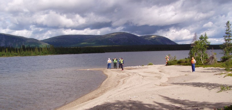
For the emergence of glaciers, even in this polar region, it is necessary that the snow that fell in winter does not melt throughout the year, accumulates, compacts and turns into ice. As you can see in the photo (Figure 2), by the summer almost all the snow on the slopes of the Khibiny melts without a trace.
In order for glaciers to grind rocks, these glaciers must move intensively, and for this they need a noticeable difference in height between the glacier feeding zone and the place where it flows. As you can see in the photo, the Khibiny peaks are not so high as to provide intensive ice movement. Of course, glaciers here will also move from the tops of the mountains to their foothills, but this will be the flow of ice. Its streams, like water, will flow around the mountains without subjecting them to strong destruction.
The rounded peaks of the mountains indicate that destructive ice has also passed over them. Strictly speaking, neither the Khibiny nor the neighboring Lovozeros now have peaks. The locals call them the Khibiny tundra and the Lovozero tundra. From the mountain peaks, only mountain plateaus remained here.
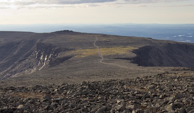
And this means that the glacier we are looking for was not formed on these peaks, but came here from the north (as evidenced by its traces on the rocks). This glacier has turned the mountain peaks into flat plateaus, moving from north to south, but in the north only the Arctic Ocean.
Well, the most mysterious question: where did the products of the destruction of mountains by the glacier go - endless moraines made of sand and stone torn off the rocks? They should have remained in any direction of movement of glaciers ...
Evidence
The path to unraveling the northern smooth rocks was not close. Eleven years, year after year, traveling around the Kola Peninsula and in the north of Karelia, I learned to read the rock paintings of the glaciers of the Arctic.
And then one day, once again crossing the Arctic Circle on the way from Tiksheozero to Notozero along the Pudos River, I unraveled all the secrets of the smooth rocks of the Arctic. At first, I was very happy to solve a problem that had haunted me for 11 years. But then, imagining those powerful cataclysms that left traces on the stones, I realized what a terrible planet we all live on.
When I learned to read the information that rocks, ice, sands and water had stored for us for tens of millions of years, the clues to many of the mysteries of our planet literally fell like a cornucopia. At one point, I understood why dinosaurs and mammoths died out, I unraveled the nature of the global flood and much more that has haunted researchers and scientists for centuries.
But at the same time, I understood the nature of those terrible cataclysms that from time to time interfered with the peaceful development of life on planet Earth. I saw not only the consequences of past disasters, but also that already charged mechanism, which is always ready for the next explosion. Moreover, I realized that this gigantic potential for planetary catastrophes is completely ignored by science in its forecasts and computer models.
So let's drink to cybernetics
From biblical times to the present day, chroniclers, screenwriters and ordinary writers competed in descriptions of the terrible punishment of heaven, natural and man-made disasters of unprecedented proportions, attacks of bloodthirsty aliens from the depths of outer space and epidemics of terrible diseases of terrestrial and extraterrestrial origin. Some or similar to the predictions of the tragedy at different times have already taken place on our planet. But reality turned out to be worse than scenarios and predictions.
Not only writers, but also scientists have repeatedly described and even simulated on computers the consequences of ancient volcano eruptions, giant earthquakes, and even meteorites or other large alien bodies falling to Earth. Scientists, with an accuracy of up to a ton, calculated the amount of dust and ash raised into the atmosphere, the size of the craters and the strength of the shock wave. Computer models with juicy colors painted us terrible destruction, fires sizzling the planet and the terrible cold of the "nuclear winter" at the same time.
But, as I found out, the possibilities of computer models are limited not by the computing power of the "iron" involved in them, but by the power of the imagination of the scientists who create these models. Because computer models implement the algorithms embedded in them by people, and as a result they give a picture that will turn out with different sets of input data. And if some factor influencing the processed data is not taken into account in the program, then the forecasts built on the basis of such a model are worthless.
Force unaccounted for
And now imagine that our planet has the Arctic Ocean on the surface of which freely floats at different times of the year from 5,000 to 25,000 cubic kilometers of ice. Free float means float freely. That is, ice moves freely on the surface of the Arctic Ocean even under the influence of ordinary wind and ordinary ocean currents (this is called ice drift) at an average speed of about 3 kilometers per day.
Looking ahead a little, I will say that it is precisely in this that the northern hemisphere of our planet is fundamentally different from its southern hemisphere. There is also ice at the South Pole, but unlike the ice of the Arctic Ocean, this ice lies motionless on the mainland of Antarctica. It cannot be moved by a simple blow of the wind or an ocean wave.
It is reasonable to ask the question: how will the floating ice of the Arctic Ocean behave in the event of a strong earthquake caused by a volcanic eruption, the movement of lithospheric plates, or a meteorite fall? Where can this mass of ice blocks move, which can be moved even by a simple wind, and not like a tsunami moving at the speed of a jet aircraft - about 700 kilometers per hour?
It is surprising that humanity is still building its future on computer models that do not take into account even such large and obvious factors as the drift of floating ice in extreme conditions. But the movement of large masses of ice can greatly affect the climate on a planetary scale.
Ice and climate
In the absence of gigantic computer power, let's turn on the imagination and build a model of the situation when, under the influence of a powerful tsunami wave, the floating ice of the Arctic Ocean will begin to move very quickly, say, at a speed of 100 kilometers per hour, and - which is very important - in a certain direction.
To simplify the task, we will analyze only two directions: by water through a wide strait between the island of Greenland and the Scandinavian Peninsula (waterway). And towards the land, for example, to the shores of Eastern Siberia, approximately along the 120th meridian (land version).
With the water option, everything is not difficult enough. Driven by the tsunami, the ice floes will float south past Iceland and Greenland along approximately the zero meridian and end up in the North Atlantic. But they won't stay there for long. Having wasted kinetic energy, the ice floes will stop, and then many of them will return back to the Arctic Ocean, carried away by a powerful current that arose due to the difference in ocean levels after the tsunami and the ejection of part of the ice.
Some of the icebergs will live out their lives in the Atlantic, but most likely there will not be strong climate changes. It will get colder in Europe and a little more in North America. Further south, the ice floes will not be able to advance due to the Gulf Stream, which blocks the entire Atlantic Ocean from the Caribbean to the Norwegian Sea.
Another thing is the land version. Here the consequences will be more serious, regardless of the direction of ice movement.
What you see is not the Arctic or the Arctic Ocean. And it's not a tsunami. It's just a wind in the Ukrainian city of Berdyansk on the Sea of Azov. March 2014.
If the tsunami wave is not very strong, it will overwhelm the shores into the depths of the mainland for several tens of kilometers and cover all this space with a thick layer of ice. After all, the thickness of ice in the Arctic Ocean is about 2-3 meters, but ice hummocks can be much thicker than the ice itself.
But if we are talking about an extraordinary event on the scale of a very large meteorite falling to the Earth, then lands covered with ice can be many hundreds and even thousands of kilometers deep into the mainland. But this is a disaster with a sequel.
A disaster with a sequel
For the climate of the planet, it is important not just the amount of ice, not only its weight or volume. The most important factor for climate is the area of ice that comes into contact with the surrounding air or water. It is air and water that carry the cold of ice around the planet and turn simple cold into a cold climate.
Now let's look at the result of such a tsunami in terms of climatology.
Part of the ice was washed up on the shore by a wave, but at the north pole it did not become warmer, and the area of ice floating there was soon restored. Thus, the area of the planet covered with ice instantly increased due to the ice thrown ashore.
With atmospheric air and water flows, this cold quickly spread throughout the Earth, significantly changing its climate in the direction of cooling. Here it is a simple and logical mechanism of instant cooling on the entire planet. On a sufficient scale, such a release of ice on land could kill not only cold-blooded dinosaurs, but also giant mammals of antiquity - mammoths.
ice Age
Approximately so there were ice ages on our planet. For the next glaciation of the northern hemisphere, a strong ocean wave was enough to throw a sufficient amount of ice onto the shores of the Arctic. But this is only the beginning of the ice epic.
So, the ice washed ashore in a matter of minutes. It will take a few more hours, days or weeks for the winds and water to carry this cold across the planet. It is done. What's next?
Оказавшись на берегу лёд сразу начинает растекаться и таять, если это случилось летом. Так как летом тепло даже на берегах Северного Ледовитого океана. А если выброс льда произошел в зимнее время, то лёд просто растекается, захватывая всё большие территории суши. Такова природа льда - он обладает текучестью. Но летом он обязательно начнет таять под действием солнечного тепла.
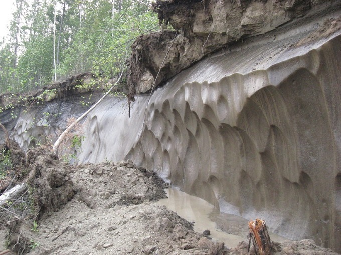
This picture clearly shows that the ice lies on light and rocky ground, and on top it is covered with a darker fertile layer that already looks like soil.
When the ice melts, then all the stones, pebbles and other impurities stored in its thickness gradually "float" to the surface of the glacier and accumulate there (such is the nature of ice). Over time, a covering moraine is formed on the surface of the glacier from stones, pebbles, dust and ash - something similar to a fertile layer, which begins to "populate" with northern vegetation.
Being covered with vegetation, the glacier turns into what we used to call permafrost. But from this the glacier does not cease to be a glacier and continues to live according to the laws of ice. Vegetation cover does not stop the melting of ice, but greatly slows it down, stretching this process for millennia.
Permafrost trail
Now that we know the physics and mechanics of permafrost formation, we have to realize the scale of ancient ice disasters in their footsteps in the form of permafrost rocks that have survived to this day.
Yes Yes exactly! These vast expanses, occupying a quarter of the land mass of the northern hemisphere of the planet, were at various times covered with ice from the Arctic Ocean. It's hard to believe, but there is convincing evidence that time cannot erase.
This video gives some insight into the cosmic power stored in the Arctic ice. Although this is just a separation of a not very large iceberg from a glacier on the west coast of Greenland. These shots were taken in the ice fjord of Ilulissat, not far from the archaeological site called Sermermiut.
Ice, which has survived to this day in the form of permafrost, was thrown out by natural disasters on different shores of the Arctic Ocean at different periods of the development of our planet. Under conditions of a general cooling of the climate throughout the planet and under the cover of vegetation, ice has been preserved for many thousands of years. During this time, other similar eruptions of ice can occur, which will additionally cool the planet's climate and make all the permafrost on Earth even more durable.
The floating ice of the Arctic Ocean is a source of very great danger to all living and non-living things on Earth. Their emissions onto land can not only physically destroy a lot, they dramatically change the climate throughout the Earth, leaving nothing living with the slightest chance to adapt or migrate to warmer climes. It is very likely that the mass extinctions of all living things, through which the evolution of life on our planet has repeatedly passed, were associated precisely with the ejection of polar ice.
Earth Cross
The ocean at the north pole and the free-drifting ice fields that form in it have played a very important role in the history of the Earth. To assess the significance of this factor, let's mentally simulate the onset of the next ice age.
In the event of a very strong earthquake caused by the movement of lithospheric plates or the fall of a large meteorite to Earth, which has happened more than once in the history of our planet, the ice of the Arctic Ocean, together with ocean water, can be completely or partially thrown ashore.
The area of permafrost on the planet is 35 million square kilometers. The vast majority of it is located in the northern hemisphere of the globe. And the area of drifting ice in the winter season reaches 15 million square kilometers. Two or three such emissions are enough to cover the earth with ice over the entire area occupied by permafrost today. But the history of the Earth knows as many as 5 mass extinctions, each of which can be associated with a similar release of ice.
Of course, it must be a very strong earthquake and a giant tsunami wave. But in order to cover the whole of Eastern Siberia, Canada and Alaska with permafrost, it is not necessary to throw ice all the way to Lake Baikal or to Lake Huron. Ice has the property of fluidity and, once on land, it begins to spread like dough on a table and flow along the curves of the terrain.
So, a powerful wave throws many hundreds of thousands of tons of ice onto land, which, moving at the speed of a tsunami (about 700 kilometers per hour), sweep away everything in its path. Ice flying at the speed of a jet aircraft erases entire mountains into sand and small gravel, which are carried away by ocean water flows far south from the scene.
This is how we found the answer to three questions at once, formulated at the beginning of the story:
-
How did local glaciers arise, where is their feeding zone?
-
What forces set these glaciers in motion?
-
Where did the products of the destruction of rocks by these glaciers go?
Glaciers originated in the Arctic Ocean from frozen ocean water and precipitation. Ice floating on the surface of the water is easily moved even by ordinary winds and ocean currents, and even more so by powerful tsunamis. Ocean ice, carried ashore at high speed by powerful waves, in a matter of minutes or hours erased entire mountains into sand and polished coastal rocks, and the products of their destruction were carried away far to the south, where they still lie in the form of sandy deserts.
What does water do
A huge amount of ocean water poured onto the land, and with it the ice - also water, only frozen. This led to a sharp drop in the level of the Arctic Ocean, and, according to the law of communicating vessels, the waters of the North Atlantic poured into it through a wide and deep strait between the Scandinavian Peninsula and Greenland. The narrow and shallow Bering Strait most likely did not have time to play a significant role in this water symphony.
The sharply decreasing waters of the North Atlantic "pulled" water from the equatorial part of the Atlantic, and then from the southern part of the Atlantic Ocean, involving the waters of the Indian and Pacific Oceans in the movement. The ocean waters are moving.
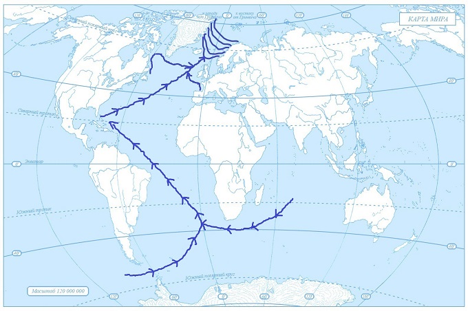
But the level difference that moved all the ocean water on Earth from its place was not eternal. When the levels of all the oceans again came into balance, the colossal inertia of moving water was left to act. This water flowed from the south to the north of the Atlantic for a long time, having a very noticeable effect on the climate of the entire planet.
So, huge masses of cold water from the Arctic Ocean, along with ice, splashed onto land, and instead of them, relatively warm waters from the Atlantic poured into the Arctic. In addition, a powerful meridional current was launched under the general name of the Gulf Stream, carrying not only water, but also large masses of thermal energy from the southern hemisphere of the planet to the equator and further to the northern hemisphere.
What happened to the climate
Everything I said above actually happened very quickly. Ice and water flew to land at the speed of a tsunami. This could take from several hours to several days.
The formation of the Gulf Stream was much slower. It's no joke - to budge such a mass of water at a distance from pole to pole. But the difference in water levels in the oceans - everything is within the power.
Thus, in the northern hemisphere it became very sharp and very cold. Later, this cooling spread to the entire globe by air currents. And in a matter of weeks, a very cold climate was established on Earth. What we used to call the ice age has come.
As you can see, the ice age came by historical standards instantly. Such a dramatic change in climate could well lead, and in fact led, to the mass extinction of all life on the planet, since life did not have the opportunity to migrate so quickly, much less adapt to the new climate.
Later, the flow of ocean water from the south pole across the equator to the north pole softened the Earth's climate somewhat, but this no longer mattered to life. Almost all living things have already died, and in the vacant living space, those few species that managed to survive a sharp cold snap began to breed and evolve.
In contrast to the prevailing opinion of climate optimists that the onset of ice ages on Earth is a matter of many centuries, if not millennia, we see that a severe cooling could occur instantly. This is also evidenced by the data of reconstruction of paleotemperatures.
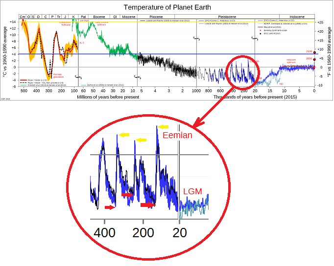
With red arrows, I have marked the starting points of global warming, and with yellow arrows, the end points of warming. The range of average annual temperatures here is about 6°C. As we can see, in the last four cases, warming occurred almost instantly on a historical scale.
But it should be borne in mind that the reconstructed temperature graphs quite accurately reflect the absolute readings of the thermometer, but the real rate of temperature changes should be estimated from them, adjusted for the real geography of events. If the cooling is due to the ejection of ice in Siberia, and we are restoring temperatures from ice cores from Antarctica, we must take into account the loss of time for the transfer of climate indicators from the Northern Hemisphere to the Southern.
In this case, the climate in the Northern Hemisphere will change almost instantly, and these changes will be reflected in the ice layers in Antarctica in a time-smoothed form.
Then comes a period of relatively stable and cold climate, the duration and nature of which is determined by the characteristics of ice melting. This stable period ends with a sharp warming. And here the main factor is the specifics of the destruction and melting of the Earth's ice cover.
How ice melts
Ice is the main source of cold on our planet. If there is a lot of ice, the climate gets colder; if there is less ice, the climate gets warmer. In light of this, the process of melting glaciers should be considered especially carefully.
But first, let's look at how ice affects the Earth's climate.
Ice, as a source and accumulator of planetary cold, affects the climate both by its own movements and through the movements of refrigerants, which are atmospheric air, water washing ocean ice, and melt water flowing from under glaciers. Water and air carry the cold of ice around the globe, changing the climate in different places in different ways.
Thus, the melting of ice, like its freezing, changes the climate on the entire planet in the most direct and significant way.
Most importantly, ice melts only on its surface, that is, where it comes into contact with other substances that have a positive temperature. No matter how hot it is, there is no melting inside the ice massif. In other words, the surface area of the ice is important for the climate, and not its mass or the physical volume of the ice mass.
Second in importance: the melting surface of the ice increases rapidly and many times over when it is destroyed. Each crack in the ice mass increases the contact area of the ice with the environment. Even more dangerous is the development of thermokarst phenomena - the thawing of ice caves and under-ice rivers of melt water. Thermokarst caves are usually filled with melt water and develop very quickly, but their volume and growth rate cannot be estimated from the outside.
Any meteorological phenomenon has its place in the geography of our planet, and its consequences are carried by atmospheric air, ocean currents and river flows throughout the Earth. But losing the idea of the changes of melting ice, we lose the idea of the development of global warming on our planet forever.
Where is our planet now
The climate of the Earth is currently in the process of actively emerging from the Ice Age. This means that the remnants of ice formed on the planet as a result of ejection from the Arctic Ocean began to melt quickly, and the area of the huge ice sheet is rapidly decreasing.
The ice sheet that forms the current climate consists of two parts: it is the floating ice of the Earth's oceans, which is clearly visible from the outside; and these are glaciers on land, most of which are disguised as "permafrost", as a result of which they are invisible to the human eye. The ice of the oceans melts in the summer and renews itself in the winter, since there is always enough water in the ocean for this. The permafrost ice melts and never recovers.
To restore the "permafrost" area, water is needed, but it is not available, due to the fact that the melt water of the "permafrost" flows through the features of the relief, cracks and thermokarst gullies in the ice. This water fills the rivers flowing through the "permafrost", which sparkle with high water in the summer and almost completely stop in the winter.
What we didn't notice
Mankind greatly exaggerates its knowledge of the surrounding nature, and also overestimates its power over it. We forgot that our planet has existed for more than four billion years, and we - humans - have been digging on it for only a few millennia.
What we proudly call science exists only for 3-4 thousand years. Even with the unmistakable recognition of scientific arguments and conclusions, we cannot boast that we have covered the entire history of the Earth with our knowledge. Especially when it comes to such comprehensive concepts as the climate of an entire planet.
We have missed one of the most important concepts of climate - the thawing of permafrost. And we will never recover much in this long process.
From the uncontrollably melting permafrost, not only thawed viruses and other very ancient microorganisms have already crawled out on us. From the uncontrollably melting permafrost, global warming has crawled out on us, the cost and consequences of which we have yet to learn.
Каждый ваш вклад имеет большое значение. Поддержите независимые научные исследования автора и помогите более глубоко изучать важные темы сегодняшнего дня
Пополнить банку на независимые научные исследования
Author: Sergii Prosvietov
Просмотров всего: 451362 Просмотров сегодня: 136
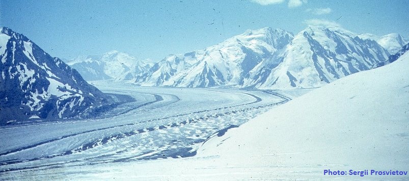
Coldness Has a Memory
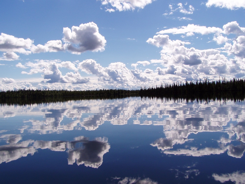
Climate Memory